
|
|
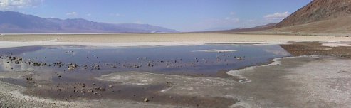
The Badwater Basin is the lowest place in the western hemisphere at 282 feet below mean sea level. |
The view here is looking north across the basin. The water you see here is heavily salted and the area around it is a salt plain. Surprisingly, despite the heat and salt there are small shrimp living in the water.
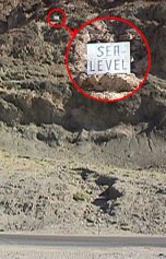
| How do we know this is 282 feet below mean sea level? Besides the official map and sign at the parking area, across the road is a cliff that shows where sea level really is. You can see here how far down that is (the inset shows the sea level sign in detail). |
|
The valley is actually sinking at a rate of about an inch a year, but also filling in at about an inch a year from debris washing down out of the mountains. So, Badwater is likely to remain the low spot for some time to come.
OK, that's the basic North/South tour. Let's now look at some miscellaneous places around the Valley; starting with the ghost town Rhyolite...
Comments? Please use the contact
page form.
Copyright © 2002
Tom Simondi, All Rights Reserved